Inca Trail to Machu Picchu: 4-Day and 2-Day Hike Guide
42 km in 4 days from Km 82 to Machu Picchu over Dead Woman's Pass at 4,215 m. Day by day, difficulty, February closure, porters and the 2-day trail.
The classic Inca Trail is a 4-day hike of about 42 km (26 mi) from Km 82 (about 2,600 m / 8,530 ft) to Machu Picchu (2,430 m / 7,970 ft), crossing Dead Woman's Pass at 4,215 m (13,829 ft). Permits are limited and sold only through authorized agencies, the trail closes every February, and May to September are the driest months. Ours starts from US$797.
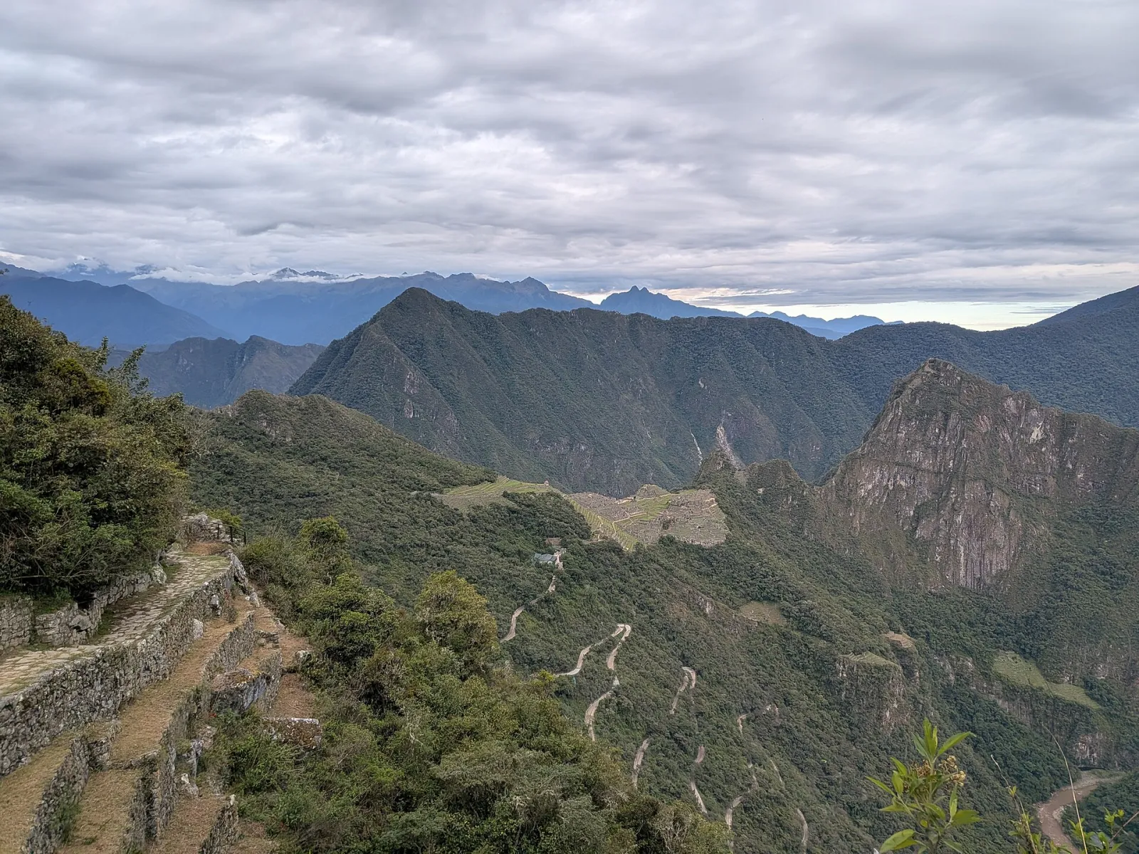
Day 4, 6:28 a.m.: the first view of Machu Picchu from Inti Punku, with the trail cut into the slope on the left. Photo: Bastian Greshake Tzovaras, CC BY-SA 4.0
Quick facts
| Classic Inca Trail | Source | |
|---|---|---|
| Length | about 42 km (26 mi) | SERNANP, cited by Wikipedia |
| Duration | 4 days, 3 nights camping | Our itinerary |
| Start | Km 82 (Piskacucho), about 2,600 m (8,530 ft) | Wikipedia, our itinerary |
| Highest point | Warmiwañusca, Dead Woman's Pass, 4,215 m (13,829 ft) | Wikipedia, our itinerary |
| End | Machu Picchu, 2,430 m (7,970 ft), via Inti Punku | Wikipedia |
| Closed | Every February, for maintenance | Andina, Dec 2025, La República, Jan 2026 |
| Permits | Limited daily spaces, booked and paid only through authorized agencies | Andina, Dec 2025 |
| Our price | From US$797 per person | Viajes Cusco Perú prices |
Who organizes your trek. Viajes Cusco Perú is not an Inca Trail operator. When you book the Inca Trail with us, we organize it with an operator authorized by SERNANP, Peru's protected areas service, and we handle the paperwork, the dates and your days in Cusco around it.
The short version
- Four days, three nights in tents, walking roughly 10 to 16 km (6 to 10 mi) a day.
- Day 2 is the hard one: about 1,200 m (3,900 ft) of climbing to Dead Woman's Pass.
- You need a permit and a guide. Permits are tied to your passport and sell out months ahead. Our Inca Trail permits guide explains how they work.
- Closed in February. It reopens on March 1.
- Short version: a 2-day Inca Trail from Km 104 also exists, with one day of hiking.
- No permit left? Salkantay and the Inca Jungle Trail need none.
What is the Inca Trail, exactly?
The Inca Trail is a stretch of original stone road that the Incas built through the mountains to Machu Picchu, part of the Qhapaq Ñan, the Andean road system UNESCO inscribed as World Heritage in 2014. It runs inside the Historic Sanctuary of Machu Picchu, a protected area SERNANP describes as created on January 8, 1981, with 32,592 hectares (about 80,500 acres). That is why the rules are strict: daily quotas, mandatory guides and control posts along the way.
What makes it different from every other way to reach Machu Picchu is the arrival. You do not come up by bus from Aguas Calientes. You walk in from above, through Inti Punku, the Sun Gate, and the citadel appears below you.
What happens on each day of the 4-day Inca Trail?
Each day climbs or drops through a different landscape, from dry valley to high grassland to cloud forest. Campsites are assigned by the authorities and can change, so take the names below as the usual pattern.
| Day | Route | Highest point | Usual camp |
|---|---|---|---|
| 1 | Km 82, Llactapata, Wayllabamba | about 3,000 m | Wayllabamba, about 3,000 m (9,840 ft) |
| 2 | Llulluchapampa, Warmiwañusca, Pacaymayo | 4,215 m (13,829 ft) | Pacaymayo, about 3,600 m (11,810 ft) |
| 3 | Runkurakay, Sayacmarca, Phuyupatamarca, Wiñay Wayna | about 3,750 m (12,300 ft) | Wiñay Wayna area |
| 4 | Inti Punku, Machu Picchu | about 2,700 m | Night in Cusco |
Day 1: Km 82 to Wayllabamba
The van leaves Cusco before dawn. At Km 82, on the Urubamba river near Piskacucho, you show your passport and permit at the checkpoint and cross the bridge. The first day is the warm-up: a path along the river, cactus and dry scrub, and then the terraces of Llactapata spread on the valley floor below the trail. You reach camp at Wayllabamba, a village at about 3,000 m, in the afternoon. Pack animals are only allowed up to here, according to Wikipedia. From this point on everything is carried by people.
Day 2: Dead Woman's Pass
This is the day people talk about. From Wayllabamba the trail climbs steadily through woodland to the open meadow of Llulluchapampa at about 3,800 m (12,500 ft), then straight up the bare slope to Warmiwañusca at 4,215 m (13,829 ft). The name means "dead woman" in Quechua. That is about 1,200 m of climbing on stone steps in one morning.
At the top there is wind, cold and a view back over the whole valley. Then the trail drops about 600 m in 2.1 km (1.3 mi) to the camp at Pacaymayo, steep steps that are hard on the knees. Most groups arrive in time for a late lunch and an early night.
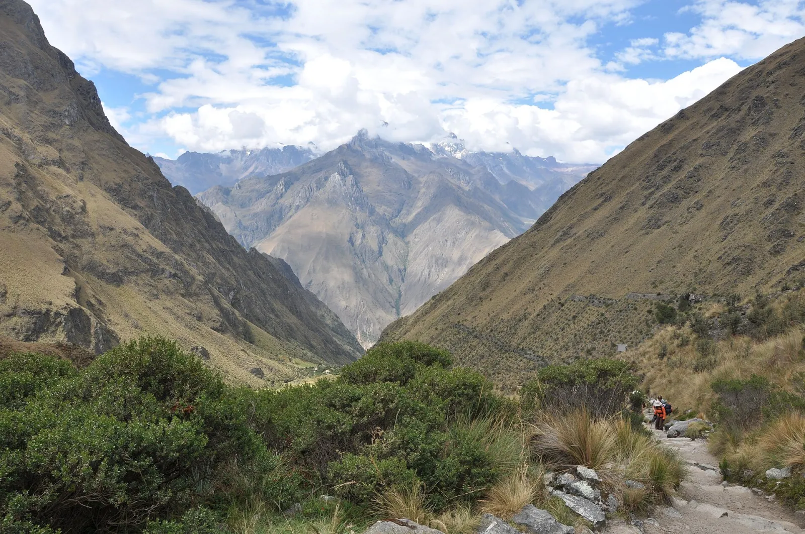
At the Warmiwañusca pass, looking back over the valley climbed on day 2. Photo: Dmitry Brant, CC BY-SA 4.0
Day 3: the ruins day
Many hikers call day 3 the best of the trek. You climb to Runkurakay, a round Inca shelter at about 3,750 m (12,300 ft), cross a second pass and then follow original Inca paving past Sayacmarca, a stone town built on a ridge. The vegetation changes as you go: orchids, mosses and cloud forest. Near Phuyupatamarca, at about 3,650 m, Wikipedia counts roughly 1,500 steps dropping about 1,000 m toward the terraces of Intipata and the ruins of Wiñay Wayna, with their channels and ritual baths fed by up to 19 springs. Camp is the last one before Machu Picchu.
Day 4: Inti Punku and Machu Picchu
The alarm goes off in the dark, because the last stretch starts before sunrise. It is about 3 km (1.9 mi) from Wiñay Wayna to Inti Punku, ending in a steep stone staircase. Then you step through the stone gate and Machu Picchu is there, below, with Huayna Picchu behind it.
You walk down into the citadel for a guided visit. Since 2025, a Ministry of Culture resolution (RM 000306-2025-MC) lets Inca Trail hikers continue into the Llaqta on Circuit 3-B, with its own daily spaces. Our Machu Picchu tickets guide explains the circuits. In the afternoon you take the bus down to Aguas Calientes and the train back toward Cusco.
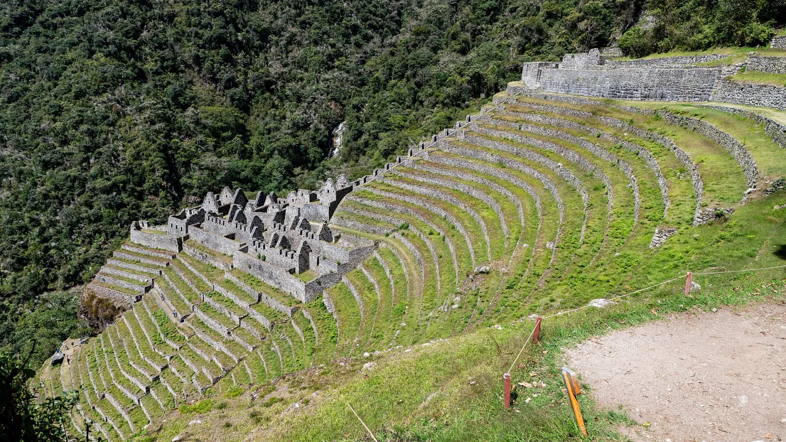
Wiñay Wayna, the last Inca site before the Sun Gate, in August. Terraces drop down the slope toward the Urubamba river. Photo: Christoph Strässler, CC BY-SA 2.0
How hard is the Inca Trail?
It is a demanding trek for fit walkers, not a technical climb. You walk 10 to 16 km a day on uneven stone steps, with about 2,500 m (8,200 ft) of total ascent according to Wikipedia and a high point above 4,200 m. The descents are as tiring as the climbs. What decides your experience is acclimatization and your knees, more than speed.
- Arrive in Cusco at least two or three days before. The CDC lists Cusco at about 3,350 m (11,000 ft) and warns never to go higher to sleep while you have symptoms of altitude illness. Our acclimatization guide explains how to use those days.
- Train on stairs in the weeks before, with a loaded daypack.
- Bring trekking poles with rubber tips. Metal-tipped poles are not allowed on the trail, according to Wikipedia.
What is the 2-day short Inca Trail?
The short Inca Trail is one day of hiking plus one day at Machu Picchu, starting at Km 104 instead of Km 82. The route, called Route 5 or Chachabamba, climbs from the train line to Wiñay Wayna and continues to Inti Punku. Wikipedia describes the hike as 6 to 7 hours. You walk into Machu Picchu through the Sun Gate in the afternoon, sleep in Aguas Calientes and visit the citadel the next morning.
It suits travelers who want the Sun Gate arrival without camping or the 4,215 m pass. It still needs a permit and a guide. We do not list the short Inca Trail as a package, so if you want the train and a night in town without the hike, see our Machu Picchu train tour in 2 days and the Aguas Calientes guide.
Do you need a permit and a guide for the Inca Trail?
Yes, both. You cannot buy a permit yourself: spaces are limited each day and must be booked and paid through authorized agencies, according to Andina. Every hiker walks with a licensed guide, and the permit carries your passport details. We explain the quota, the sale dates and the months that sell out first in our Inca Trail permits and availability guide, so we will not repeat it here.
When is the Inca Trail closed?
Every February, for maintenance. In January 2026 La República reported that the trail would close from January 31 and reopen on March 1, with work by the Machu Picchu Archaeological Park on retaining walls, paths, bridges, campsites and rockfall prevention. Andina confirmed there would be no treks in February 2026.
Rain can also close it outside February. On August 20, 2026, a report on lacamara.pe said SERNANP and the Ministry of Culture had closed routes 1, 2 and 3 of the Inca road network from August 18 to 22 after landslides, while Route 5 from Km 104 stayed open. In April 2025 Caretas reported that the Wiñay Wayna campsite was temporarily closed for overnight stays after rain damage. Your operator rearranges camps when this happens.
When is the best time to hike the Inca Trail?
May to September, the dry season. The table uses SENAMHI's 1991 to 2020 normals for the Machu Picchu station at 2,399 m, the closest official reference to the end of the trail.
| Months | Rain at Machu Picchu | What it means on the trail |
|---|---|---|
| May to September | July averages 54 mm | Driest, cold nights at the pass, permits sell out first |
| October and April | April averages 184 mm | Shoulder months, showers, greener slopes |
| November and December | 173 and 275 mm | Rain most days, muddy steps |
| January and March | about 341 mm each | Wettest months the trail is open |
| February | 325 mm | Closed |
For the season-by-season picture of the whole trip, see our best time to visit Machu Picchu.
Who are the porters, and how much should you tip?
Porters are the men and women who carry the tents, kitchen and food, and often run ahead to have camp ready when you arrive. In June 2024 SUNAFIL, Peru's labor inspection agency, said the load limit under the porter law is 20 kg for men and 15 kg for women.
Tips are voluntary and expected. Guidance published in mid-2026 by New Peruvian suggested a total of about S/200 to 300 per hiker for the whole crew. Bring soles in small notes. Our money and tipping guide has the details.
Inca Trail, Salkantay or Inca Jungle: which should you choose?
Choose the Inca Trail for the ruins and the Sun Gate arrival, Salkantay for high mountain scenery without a permit, and the Inca Jungle for adventure sports. This is a short table. The full comparison is in Salkantay trek vs Inca Trail.
| Classic Inca Trail | Salkantay Trek | Inca Jungle Trail | |
|---|---|---|---|
| Days | 4 | 5 | 4 |
| Highest point | 4,215 m | a pass above 4,600 m | Abra Málaga, 4,300 m, by bike |
| Permit | Yes, sells out | No | No |
| Nights | Camping | Glamping or cabins, hotel in Aguas Calientes | 3 hotel nights |
| Arrival at Machu Picchu | On foot through Inti Punku | Via Aguas Calientes | Via Aguas Calientes |
| From | US$797 | US$707 | US$607 |
Salkantay and Inca Jungle details come from our tour notes. If you want living culture more than ruins, the Lares trek in 4 days, from US$787, also needs no permit.
What should you pack?
A daypack with water, snacks, a rain jacket, a warm layer for the pass, sunscreen and a headlamp for the last morning. Waterproof boots with good grip, because wet stone is slippery. Your passport, the same one used for the permit. Cash in soles for tips and the toilets at Machu Picchu. The rest of the list is in our Peru packing list.
What we do and what we don't
We are Viajes Cusco Perú, a travel agency in Cusco. We are not an Inca Trail operator and we do not employ the trail crew. We organize your trek with an operator authorized by SERNANP and handle the booking, the dates and the days around it. Our price list says the Classic Inca Trail in 4 days includes the permit, a bilingual guide, porters, meals on the trail, camping gear, transport to Km 82 and the bus down from Machu Picchu. We cannot sell a permit for a date that is already sold out, and we cannot reopen the trail in February. If a date is gone, we will tell you and suggest an alternative.
Frequently asked questions
How long is the Inca Trail to Machu Picchu? About 42 km (26 mi) on the classic route from Km 82, walked in 4 days and 3 nights.
What is the highest point of the Inca Trail? Warmiwañusca, or Dead Woman's Pass, at 4,215 m (13,829 ft). You cross it on day 2.
How hard is the Inca Trail hike? Demanding but not technical. Expect 10 to 16 km a day on stone steps, a big climb on day 2 and long descents.
Can I hike the Inca Trail without a guide? No. Every hiker needs a licensed guide, and permits are sold only through authorized agencies.
Is the Inca Trail closed in February? Yes, every year, for maintenance. In 2026 it closed on January 31 and reopened on March 1.
What is the best month to hike the Inca Trail? May to September, the dry season. July is among the driest months at Machu Picchu.
What is the short Inca Trail? A 2-day version that starts at Km 104, hikes 6 to 7 hours past Wiñay Wayna to the Sun Gate and visits Machu Picchu the next day.
How far in advance should I book the Inca Trail? For June to August, many months ahead. Our permits guide lists the lead time for each month.
How much weight do porters carry? The porter law limit is 20 kg for men and 15 kg for women, according to SUNAFIL.
Is the Inca Trail better than Salkantay? The Inca Trail has more ruins and the Sun Gate arrival. Salkantay has higher mountains and needs no permit.
Do I need to acclimatize before the Inca Trail? Yes. Spend at least two or three days in Cusco or the Sacred Valley before you start.
Plan your Inca Trail with us
Start with the Classic Inca Trail in 4 days, from US$797 per person, organized with a SERNANP-authorized operator. If permits are gone for your dates, the Salkantay trek in 5 days, from US$707, and the Inca Jungle Trail in 4 days, from US$607, both end at Machu Picchu without a permit. For something remote, there is the Choquequirao trek in 4 days from US$767. All our hikes are on the Cusco trekking page.
Updated October 2026. Distances, altitudes, closures and rules checked on October 20, 2026, against Andina (December 2025, June 2024), La República (January 2026), lacamara.pe (August 2026), Caretas (April 2025), SERNANP's page on the Historic Sanctuary of Machu Picchu, the CDC Yellow Book, SENAMHI climate normals for the Machu Picchu station and the Wikipedia entry for the Inca Trail to Machu Picchu. Campsites and rules change, so confirm them with us before you travel.